Table of Contents
List of Tables
3.3.1 Introduction
This section provides information on the RADARSAT-1 data collected during the project. All RADARSAT-1 data for this project was acquired at the Canadian Ice Service (CIS) via the satellite reception facility at Gatineau, Quebec. This raw CEOS data was ingested at CIS and processed into the native georeferenced ERDAS Imagine format (IMG). The raw CEOS data was then 2x2 block-averaged and is stored on CD-ROM in the CIS Image Archive.
Back to Table of Contents3.3.2 Sensor Description
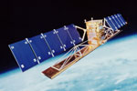
RADARSAT-1 was developed by Canada to monitor environmental change and to support resource sustainability. The satellite was launched on November 4th 1995 armed with a Synthetic Aperture Radar (SAR). The SAR is a powerful microwave instrument that can transmit and receive signals to "see" through clouds, haze, smoke, and darkness, and obtain high quality images of the Earth in all weather at any time. This provides significant advantages in viewing under conditions that preclude observation by aircraft and optical satellites. These SAR characteristics are listed in Table 3.3.1.
| SAR Characteristics | |
|---|---|
| Frequency / Wavelength | 5.3GHz/C-band 5.6 cm |
| RF Bandwidth | 11.6, 17.3 or 30.0 Mhz |
| Transmitter Power (peak) | 5 kW |
| Transmitter Power (average) | 300 W |
| Maximum Data Rate | 85 Mb/s (recorded) - 105 Mb/s (R/T) |
| Antenna Size | 15m x 1.5m |
| Antenna Polarization | HH |
The satellite can acquire imagery in a number of different resolutions and swath widths. Refer to Table 3.3.2 for a summary of the sensor's imaging modes and other swath information. It should be noted that data for this project was only acquired in ScanSAR Wide Imaging mode.
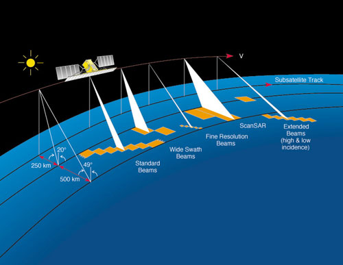
| Imaging Modes | ||||
|---|---|---|---|---|
| Mode | Nominal Resolution (m) | No. of Positions / Beams | Swath Width (km) | Incidence Angles (degrees) |
| Fine | 8 | 15 | 45 | 37 - 47 |
| Standard | 30 | 7 | 100 | 20 - 49 |
| Wide | 30 | 3 | 150 | 20 - 45 |
| ScanSAR Narrow | 50 | 2 | 300 | 20 - 49 |
| ScanSAR Wide | 100 | 2 | 500 | 20 - 49 |
| Extended High | 18 - 27 | 3 | 75 | 52 - 58 |
| Extended Low | 30 | 1 | 170 | 10 - 22 |
3.3.3 Orbit Characteristics
The satellite's near-polar, sun-synchronous orbit ensure near-complete global coverage and similar illumination conditions for data collected at the same latitude and the same time of year. The satellite crosses the equator at dawn and dusk and is rarely in eclipse, and is therefore able to acquire data at any time. RADARSAT-1's orbit coupled with the Earth's rotation about its axis sees data collected in two directions: north-to-south (descending pass) and south-to-north (ascending pass). Table 3.3.3 provides more orbital information.
| Orbit Characteristics | |
|---|---|
| Altitude | 793-821 kilometres |
| Inclination | 98.6 degrees |
| Period | 101 minutes |
| Ascending node | 18:00 hours |
| Sun-synchronous | 14 orbits per day |
3.3.4 Data Format
Data files are available in three formats:
- 2x2 Block-averaged RAW CEOS. Data in this block-averaged format is 8-bit data. The 2x2 block averaging process which reduces pixel size to 100m.
- Erdas Imagine native format (IMG)
- Quicklook JPEG (JPG)
Data collected for this project is listed in Table 3.3.4.
| Date | Time (Z) | Beam | IMG | RAW CEOS | CD Vol | JPG |
|---|---|---|---|---|---|---|
| 02/25/2003 | 10:41 | SCW-A | r_0000_1_25fb03_1041_1087462.img | R1_030225_104119_01.sard.avg | 1013 | R1_030225_104119_01.jpg |
| 02/25/2003 | 22:02 | SCW-A | r_0000_1_25fb03_2202_1087674.img | R1_030225_220246_01.sard.avg | 1013 | R1_030225_220246_01.jpg |
| 02/25/2003 | 22:04 | SCW-A | r_0000_2_25fb03_2204_1087680.img | R1_030225_220402_02f.sard.avg | 1013 | R1_030225_220402_02f.jpg |
| 02/26/2003 | 10:11 | SCW-A | r_0000_1_26fb03_1011_1088194.img | R1_030226_101127_01.sard.avg | 1014 | R1_030226_101127_01.jpg |
| 02/26/2003 | 10:12 | SCW-A | r_0000_2_26fb03_1012_1088195.img | |||
| 02/26/2003 | 21:33 | SCW-A | r_0000_1_26fb03_2133_1088390.img | R1_030226_213348_01.sard.avg | 1014 | R1_030226_213348_01.jpg |
| 02/27/2003 | 09:43 | SCW-A | r_0000_3_27fb03_0943_1089040.img | R1_030227_094317_03.sard.avg | 1015 | R1_030227_094317_03.jpg |
| 02/28/2003 | 22:15 | SCW-A | r_0000_1_28fb03_2215_1090271.img | R1_030228_221556_01.sard.avg | 1015 | R1_030228_221556_01.jpg |
| 03/01/2003 | 10:24 | SCW-A | r_0000_1_01mr03_1024_1090880.img | R1_030301_102427_01.sard.avg | 1016 | R1_030301_102427_01.jpg |
| 03/01/2003 | 10:25 | SCW-A | r_0000_2_01mr03_1025_1090920.img | R1_030301_102542_02.sard.avg | 1016 | R1_030301_102542_02.jpg |
| 03/01/2003 | 21:46 | SCW-A | r_0000_1_01mr03_2146_1091124.img | R1_030301_214605_01.sard.avg | 1016 | R1_030301_214605_01.jpg |
| 03/01/2003 | 21:47 | SCW-A | r_0000_2_01mr03_2147_1091126.img | R1_030301_214720_02f.sard.avg | 1016 | R1_030301_214720_02f.jpg |
| 03/02/2003 | 09:55 | SCW-A | r_0000_3_02mr03_0955_1091660.img | R1_030302_095553_03.sard.avg | 1016 | R1_030302_095553_03.jpg |
| 03/02/2003 | 21:16 | SCW-A | r_0000_1_02mr03_2116_1091896.img | R1_030302_211659_01.sard.avg | 1016 | R1_030302_211659_01.jpg |
| 03/04/2003 | 10:36 | SCW-A | r_0000_1_04mr03_1036_1093227.img | R1_030304_103651_01.sard.avg | 1017 | R1_030304_103651_01.jpg |
| 03/04/2003 | 10:38 | SCW-A | r_0000_2_04mr03_1038_1093249.img | R1_030304_103806_02f.sard.avg | 1017 | R1_030304_103806_02f.jpg |
| 03/04/2003 | 21:58 | SCW-A | r_0000_1_04mr03_2158_1093531.img | R1_030304_215823_01.sard.avg | 1017 | R1_030304_215823_01.jpg |
| 03/04/2003 | 21:59 | SCW-A | r_0000_2_04mr03_2159_1093537.img | R1_030304_215938_02f.sard.avg | 1017 | R1_030304_215938_02f.jpg |
| 03/05/2003 | 10:07 | SCW-A | r_0000_2_05mr03_1007_1094130.img | R1_030305_100747_02.sard.avg | 1017 | R1_030305_100747_02.jpg |
| 03/05/2003 | 10:09 | SCW-A | r_0000_3_05mr03_1009_1094150.img | R1_030305_100903_03.sard.avg | 1017 | R1_030305_100903_03.jpg |
| 03/05/2003 | 21:29 | SCW-A | r_0000_1_05mr03_2129_1094453.img | R1_030305_212937_01.sard.avg | 1017 | R1_030305_212937_01.jpg |
| 03/07/2003 | 22:12 | SCW-A | r_0000_1_07mr03_2212_1096356.img | R1_030307_221202_01.sard.avg | 1018 | R1_030307_221202_01.jpg |
| 03/08/2003 | 10:19 | SCW-A | r_0000_1_08mr03_1019_1096776.img | R1_030308_101955_01.sard.avg | 1018 | R1_030308_101955_01.jpg |
| 03/08/2003 | 10:21 | SCW-A | r_0000_2_08mr03_1021_1096825.img | R1_030308_102111_02.sard.avg | 1018 | R1_030308_102111_02.jpg |
| 03/08/2003 | 10:22 | SCW-A | r_0000_3_08mr03_1022_1096840.img | R1_030308_102226_03f.sard.avg | 1018 | R1_030308_102226_03f.jpg |
| 03/08/2003 | 21:41 | SCW-A | r_0000_1_08mr03_2141_1097046.img | R1_030308_214159_01.sard.avg | 1018 | R1_030308_214159_01.jpg |
| 03/08/2003 | 21:43 | SCW-A | r_0000_2_08mr03_2143_1097047.img | R1_030308_214314_02f.sard.avg | 1018 | R1_030308_214314_02f.jpg |
| 03/11/2003 | 10:32 | SCW-A | r_0000_1_11mr03_1032_1099253.img | R1_030311_103257_01.sard.avg | 1020 | R1_030311_103257_01.jpg |
| 03/11/2003 | 10:34 | SCW-A | r_0000_2_11mr03_1034_1099254.img | R1_030311_103412_02f.sard.avg | 1020 | R1_030311_103412_02f.jpg |